
‘Potent storm’ may dump heavy rain and bring chance of severe weather to much of Georgia
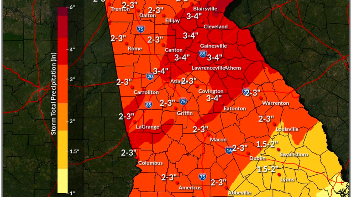
A “powerful” rain- and thunderstorm-making weather system was expected to sweep into Georgia overnight on Monday and into the day Tuesday, bringing with it an “enhanced risk” of tornadoes and gusting winds, especially in southern portions of the state.
Areas to the north of a line roughly from Columbus to Macon to Eatonton were deemed to have a “slight risk” of severe weather, while locations south of the line were in a zone of “enhanced risk,” the National Weather Service said in statements Monday.
In a message on social media, the weather service noted that the “potent storm” would bring “periods of heavy rain with 1 to 3 inches possible with isolated higher amounts,” along with a chance for some thunderstorms “becoming strong to severe.”
Another social media post from the weather service’s Peachtree City office mentioned that “the powerful storm system” was also expected to “bring heavy rainfall & the risk for localized flash flooding & river flooding, especially in urban areas and poor-drainage areas.”
The storm was expected to impact much of the South, from Mississippi to the Carolinas, with schools in some areas expected to close for the day.
According to the weather service’s forecast discussion issued Monday morning, “Severe thunderstorms that develop [Tuesday] will be capable of producing damaging wind gusts and a few tornadoes. Widespread non-thunderstorm wind gusts over 40 mph are also possible, with higher gusts across the northern mountains. Rainfall amounts of over 3 inches are possible in a swath from Columbus to Gainesville, with higher amounts across the northeastern mountains.”
More storms and rain are possible across the state on Thursday night and Friday.
This story was originally published January 8, 2024 at 12:09 PM.